

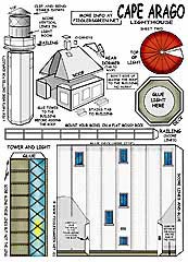
Cape Arago , OR - $$4.95
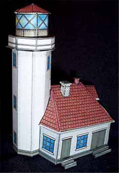
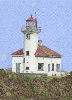
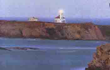
Cape Arago Lighthouse, located two miles southwest of Charleston, was built in 1934, replacing two earlier structures dating back to 1909 and 1966. The 44-foot octagonal tower rises only 100 feet above sea level with a visibility of 16 miles seaward. The active lighthouse still stands after more than a half century since its construction.The lighthouse is in good shape, but the walkway out to Lighthouse Island (aka Gregory Point) is condemned for public use; only Coast Guard personnel may use it.

Cape Arago Light House, Coos Bay, Oregon
 Cape Arago Lighthouse, located two miles southwest of Charleston, was built in 1934, replacing 9 two earlier structures dating back to 1909 and 1966.
The 44-foot octagonal tower rises only 100 feet above sea level with a visibility of 16 miles seaward. The active lighthouse still stands after more than a half century since its construction.
When Oregon's first lighthouse, at the mouth of the Umpqua River, fell over after angry waters undermined it during an October 1863 storm, the US Lighthouse Board decided not to replace it. Instead it had a new station built near Cape Arago (then called Cape Gregory), 25 miles to the south.
The prominent headland lies just south of the entrance to boomerang-shaped Coos Bay, where a rapidly developing lumber business had transformed the region into a bustling shipping center...
Cape Arago [Cape Gregory] (1866;1934)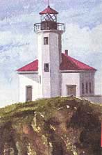
When Oregon's first lighthouse, at the mouth of the Umpqua River, fell over after angry waters undermined it during an October 1863 storm, the US Lighthouse Board decided not to replace it. Instead it had a new station built near Cape Arago (then called Cape Gregory), 25 miles to the south. The prominent headland lies just south of the entrance to boomerang-shaped Coos Bay, where a rapidly developing lumber business had transformed the region into a bustling shipping center.
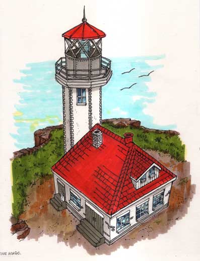
In 1864, Congress provided funds for a stubby iron tower standing on eight legs at the seaward end of a tiny islet-100 yards offshore and 2.5 miles north of Cape Arago. The 25-foot octagonal structure was capped with an iron lantern holding a revolving, fourth order Fresnel lens. Workers constructed a wood-frame keepers' house down the island and linked it to the lighthouse via a 1 ,300-foot wooden walkway.
 By the early 1900s, erosion of the outer end of the sandstone
based island was threatening both the lighthouse and a nearby
brick fog signal building, which had been added in 1896. The Lighthouse
Board responded by erecting a combination light tower/fog signal
at the opposite end of the island, presumably well away from the
ocean's reach. The light in the taller wooden structure was 100
feet above sea level and began active service in July 1909.
By the early 1900s, erosion of the outer end of the sandstone
based island was threatening both the lighthouse and a nearby
brick fog signal building, which had been added in 1896. The Lighthouse
Board responded by erecting a combination light tower/fog signal
at the opposite end of the island, presumably well away from the
ocean's reach. The light in the taller wooden structure was 100
feet above sea level and began active service in July 1909.
Surprisingly, the second light suffered the same fate as its predecessor. In 1934, the Coast Guard, concerned for the station's safety, erected a third tower further back from the crumbling cliffs. Constructed of reinforced concrete, the octagonal white sentinel received the Fresnel lens from the earlier lighthouse-and electricity.
USCG officials automated the Cape Arago station in 1966. It
continues as an active beacon.
Viewing spot: Roadside, Cape Arago Hwy, west of Charleston.
Directions: From US 101 Coos Bay, turn west onto West Commercial Ave and proceed 0.2 miles, Turn left (south) onto North 5th Stand continue a 05 miles. Turn right onto W Central Ave and go 0 5 miles. Bear right onto Ocean Blvd and continue 2 6 miles. Turn left onto Newmark Ave and go 0.6 miles. Turn left onto Empire Blvd (which becomes Cape Arago Hwy) and continue south/west another eight miles (passing through the town of Charleston en route). From the roadside (right), 0.55 miles south of Sunset Bay State Park's overnight campground entrance, the lighthouse is visible, 1.0 miles to the north.
Cape Arago
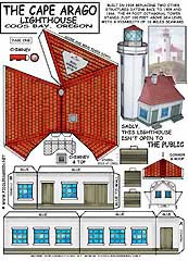
This is the third lighthouse to occupy this location. The first two built in 1866 and 1908 fell victim to weather and erosion. The third Cape Arago Lighthouse with its 44-foot tower was built of rein' forced concrete in 1934. The lighthouse is in good shape, but the walkway out to Lighthouse Island (aka Gregory Point) is condemned for public use; only Coast Guard personnel may use it. This lighthouse with its fourth order Fresnel lens still in use is maintained by the Coast Guard as is a unique-sounding fog horn.
 The light and fog signal prevented considerable ship wreck
in the vicinity of Cape Arago and many daring sea rescues were
undertaken from the old lifesaving station located on the lee
side of Lighthouse Island in the early days before and after the
turn of the century. The light keepers often alerted the surf men
when a ship was in trouble and they would launch their surf boats
and head out to sea.... In 1915, the Coast Guard took over that
branch of the service and the lifesaving station was relocated
at Charleston inside Coos Bay.
The light and fog signal prevented considerable ship wreck
in the vicinity of Cape Arago and many daring sea rescues were
undertaken from the old lifesaving station located on the lee
side of Lighthouse Island in the early days before and after the
turn of the century. The light keepers often alerted the surf men
when a ship was in trouble and they would launch their surf boats
and head out to sea.... In 1915, the Coast Guard took over that
branch of the service and the lifesaving station was relocated
at Charleston inside Coos Bay.
Cape Arago Lighthouse is located about 4 miles south of Charleston between Sunset Bay and Shore Acres state parks. Although the lighthouse is not open to the public, good views are possible from the hiking trail between the two state parks and from a turnout about a half to three quarter mile south of Sunset Bay.